Prior to 2009, most U.S. earthquakes were confined to California. Since then, the central and eastern states have experienced a dramatic surge in seismic activity and sinkhole formation. According to the U.S. Geological Survey (USGS), the region recorded 844 earthquakes of magnitude 3.0 or greater between 1978 and 2008. The same period from 2009 to 2013 saw 2,897 such events—a 343% increase—and the trend continues. In 2014 alone, over 659 earthquakes above magnitude 3.0 were logged.
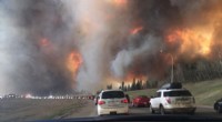
In August 2012, months of unexplained seismic tremors and bubbling in the Louisiana Bayou culminated in a massive sinkhole near the small town of Bayou Corne, 77 miles west of New Orleans. The 1‑acre opening rapidly expanded, consuming trees and growing to 34 acres over four years. State scientists attributed the collapse to the Texas Brine Company’s drilling too close to the salt dome’s outer edge, resulting in a $48.1‑million settlement with local residents.
National Aeronautics and Space Administration (NASA)
To investigate the surge, USGS installed temporary seismic stations across the affected region, enabling precise mapping of tremor origins. The data revealed a strong correlation between human activities—particularly mining, hydraulic fracturing, and wastewater injection—and induced seismicity. In 2016, USGS released its first comprehensive induced‑earthquake model that integrates both natural and anthropogenic hazards.
USGS findings emphasize that most human‑induced earthquakes stem from injecting wastewater, a by‑product of oil and gas extraction, into the ground. While re‑injecting this fluid into the same site typically poses minimal risk, drilling new wells to dispose of the wastewater in previously undrilled zones elevates subsurface pressure, frequently triggering earthquakes and, in some cases, sinkholes.
In September 2016, Arizona State University geophysicist Manoochehr Shirzaei published a study in the journal Science showing that monitoring uplift and pore‑pressure changes can predict seismic hazards. By comparing satellite radar imagery from May 2007 to November 2013 around a 4.8‑magnitude quake near Timpson, Texas, the study demonstrated that wastewater seepage increased pressure in fault zones 3.5–4.5 km deep. This model allows operators to halt injections before dangerous thresholds are reached.
The Environmental Protection Agency (EPA) and state agencies oversee permitting, construction, operation, and decommissioning of injection wells used in hydraulic fracturing and gas and oil production. EPA regulations also cover fracking that employs diesel fuels, protecting underground water resources. However, the agency does not regulate wells used solely for production, a gap that requires ongoing attention.
NASA’s synthetic aperture radar (SAR) data, collected by the C‑20A jet, flagged the Bayou Corne area as susceptible to sinkhole formation a month before the 2012 collapse. The radar detected a 10.2‑inch upward bulge preceding the event. Similar SAR analyses helped the ASU geophysicist identify pre‑seismic deformation around Timpson, Texas.
Historical evidence underscores the environmental and public‑health risks of careless mining practices, including groundwater contamination, induced earthquakes, and sinkholes. With stringent regulations, rigorous monitoring, and advanced imaging techniques, the industry can operate responsibly, safeguarding communities and ecosystems.