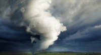
Volcanoes are the planet’s most dramatic geologic actors, revealing the dynamic forces that shape the Earth’s surface. Mount Kilauea, a shield volcano on Hawaii Island, has captivated scientists and locals alike for centuries. From its first recorded eruption in 1983 to the latest activity in September 2024, Kilauea’s relentless activity has reshaped the island’s landscape, created new land, and advanced our understanding of volcanic processes.
Douglas Peebles/Getty Images
For Hawaiians, Kilauea is more than a geological feature—it is the living embodiment of Pele, the goddess of volcanoes and fire. According to oral traditions, Pele’s eruptions formed the Hawaiian Islands, and her home is believed to reside within the summit crater, Halemaʻumaʻu. The mountain’s cultural significance underscores the importance of living in harmony with nature’s powerful forces.
Scientific documentation of Kilauea began in the early 19th century. William Ellis, an English missionary, visited the volcano on August 1, 1823, and his detailed account became the first contemporary record of its eruptions. Isotopic analyses of volcanic deposits indicate that Kilauea has been erupting intermittently since at least 4,650 B.C., making it one of the world’s most historically active volcanoes.
In 1912, the Hawaiian Volcano Observatory was established, marking the beginning of systematic monitoring. Geologist Thomas A. Jagger famously noted in 1916 that “Hawaii offers a unique laboratory for studying volcanology and the relationship between local earthquakes and volcanoes.” Today, the observatory remains a leading institution in volcanic research.
On January 3, 1983, Kilauea’s Puʻu ʻŌʻō eruption began, turning the volcano into one of the longest continuously active events in recorded history. Over 35 years, the eruption produced 1.1 cubic miles of lava, covered 60 square miles of land, and added 439 acres of new coastline to Hawaii Island’s southeastern shore.
While the eruption is often described as continuous, it actually featured hundreds of pauses—ranging from a few hours to nearly a month—when surface activity ceased. The final collapse of the Puʻu ʻŌʻō summit on April 30, 2018, ended the 35‑year event. The collapse destroyed 215 structures, buried nearly 9 miles of highway under up to 115 feet of lava, and caused the summit lava lake to drain through underground channels.
Shortly after the collapse, a new eruption ignited on May 3, 2018, in the residential area of Leilani Estates. Though brief, this episode produced 24 fissures, triggered 60,000 earthquakes, and spewed 13.7 miles of lava, creating an additional 875 acres of land.
The 2018 eruption devastated over 600 homes and displaced thousands. Communities such as Kapoho and Lanipuna Gardens were erased from the map. Federal and state agencies, alongside scientific teams, have since assisted residents in decision‑making about rebuilding on the newly formed lava fields.
Scientists leveraged social media and aerial drones to monitor the eruption, improving response times and saving lives. The event has become a benchmark for volcanic disaster response, offering lessons for communities worldwide that sit near active volcanoes.
After a two‑year lull, Kilauea reawakened in December 2020. A new eruption at the Halemaʻumaʻu crater produced a sudden lava lake that reshaped the summit crater, providing valuable data on magma reservoirs following large eruptions.
Early 2023 saw increased seismicity and ground deformation around Halemaʻumaʻu. On January 5, 2023, powerful explosions and lava fountains shot 164 feet into the air, forming a lava lake that filled roughly 2 % of the caldera. The eruption ceased after 61 days, drawing thousands of visitors to witness the glow of the lava lake.
This 2023 activity also coincided with a temporary lull in Mauna Loa’s eruptions, suggesting a possible linkage between the two volcanoes within the same hotspot system.
In June 2024, a fissure eruption occurred 2.5 miles southwest of the caldera, marking the first Southwest Rift Zone eruption since 1974. The event occurred in a remote, visitor‑restricted area, but early‑morning hikers on the Crater Rim Trail reported a reddish glow above the horizon.
On September 15, 2024, Kilauea erupted again, covering 156 acres of land from a fissure over one mile long. The United States Geological Survey described this as “a significant and fascinating change in activity.” Subsequent seismic unrest has raised the possibility of future eruptions.
The Hawaiian Volcano Observatory, now located 30 miles from the summit caldera, employs a multidisciplinary team of geologists, seismologists, and gas scientists. Using seismographs, GPS, satellite imagery, and public communication tools, the observatory keeps residents informed and aids in emergency planning.
For Hawaii Island residents, the observatory’s work is not merely academic—it is essential for their safety and continues the living mythos of Pele. As Kilauea’s story unfolds, it remains a natural marvel and a scientific frontier.
To learn more about how volcanoes form, read our guide on the Earth’s crust, lithosphere, and plate tectonics.