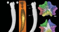
Tulane University researchers Marcello Canuto and Francisco Estrada-Belli are part of a team of researchers who uncovered ancient cities in northern Guatemala through the use of jungle-penetrating LiDAR (light detection and ranging) technology. Credit: American Association for the Advancement of Science
Tulane University researchers, documenting the discovery of dozens of ancient cities in northern Guatemala through the use of jungle-penetrating Lidar (light detection and ranging) technology, have published their results in the prestigious journal Science.
The article includes the work of Marcello Canuto, director of the Middle American Research Institute at Tulane, and Francisco Estrada-Belli, a research assistant professor at Tulane and director of the Holmul Archaeological Project since 2000. They worked with assistant professor of anthropology Thomas Garrison of Ithaca College as well as other scholars to make their discoveries in the Petén forest of Guatemala.
A consortium of 18 scholars from U.S., Europe and Guatemalan institutions including the Ministry of Culture and Sports were enabled by the Fundación PACUNAM (Mayan Heritage and Nature Foundation) to analyze lidar data covering over 2,100 square kilometers of the Maya Biosphere Reserve.
"Since LiDAR technology is able to pierce through thick forest canopy and map features on the earth's surface, it can be used to produce ground maps that enable us to identify human-made features on the ground, such as walls, roads or buildings," Canuto said.
The PACUNAM LiDAR INITIATIVE (PLI), is the largest single lidar survey in the history of Mesoamerican archaeology. The collaborative scientific effort has provided fine-grained quantitative data of unprecedented scope to refine long-standing debates regarding the nature of ancient lowland Maya urbanism. Specifically, the key identifications of this study are:
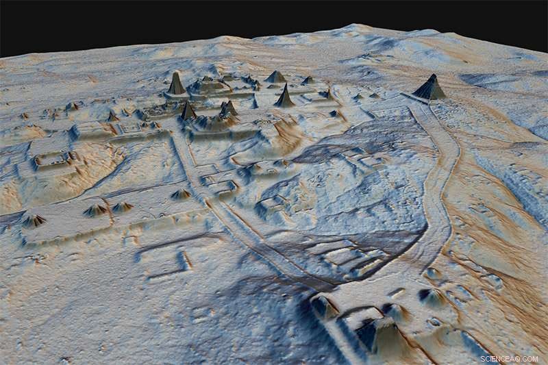
A newly-documented site to the north of Tikal illustrates the range of features uncovered by lidar, as well as the complexity of interpreting them. The elongated building at top right is part of a so-called E Group complex and may pre-date 500 BCE. Across the valley, the large acropolis is likely a thousand years younger, though it may cover earlier constructions. Its broad access ramp overlaps an earlier causeway that runs between two eroded hilltop platforms, at the top and bottom of the image. Small houses and sunken garden enclosures cover the hillsides. Credit: Luke Auld-Thomas/PACUNAM
Both Canuto and Estrada-Belli noted that discoveries were made in a matter of minutes, compared to what would have taken years of fieldwork without the LiDAR technology.
"Seen as a whole, terraces and irrigation channels, reservoirs, fortifications and causeways reveal an astonishing amount of land modification done by the Maya over their entire landscape on a scale previously unimaginable," Estrada-Belli said.
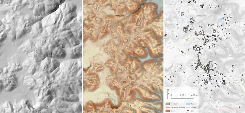
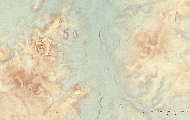
It takes months of analysis to translate lidar terrain data into meaningful archaeological interpretations. Familiar shaded relief terrain visualizations (left) can conceal subtle but important details, like low mounds or cross-channel terraces. More complex visualizations such as the Red Relief Image Map (center) make those details pop, but even so archaeologists must identify and classify features manually for subsequent analysis (right). All three images are of the site of Dos Torres, in the rugged karst hills between the cities of Tikal and Uaxactun. Credit: Luke Auld-Thomas and Marcello A. Canuto/PACUNAM