Here's a breakdown:
* Geo: Relating to the Earth.
* Morph: Refers to form or shape.
* -ology: The study of.
Geomorphologists study the Earth's landforms, including:
* Mountains: How they are formed, their evolution, and the processes that shape them.
* Valleys: The different types of valleys and how they are created by rivers, glaciers, and other forces.
* Rivers and Lakes: The flow of water, erosion, and deposition.
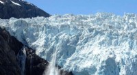
* Glaciers: The movement of ice and the impact on the landscape.
* Coastal Areas: The interaction of land and ocean, including erosion, deposition, and the formation of beaches.
They use a variety of methods, including:
* Fieldwork: Observing landforms and collecting data.
* Remote Sensing: Using satellite imagery and aerial photographs to study the Earth's surface.
* Geographic Information Systems (GIS): Analyzing spatial data and creating maps.
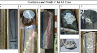
* Laboratory Analysis: Examining samples of rocks, soils, and sediments.
Geomorphologists play an important role in understanding the Earth's history, predicting future changes in the landscape, and mitigating natural hazards.