Plate tectonics is the driving force behind the formation of the Earth's surface features. It involves the movement of Earth's rigid lithosphere, which is divided into several tectonic plates. These plates move relative to each other, and their interactions create various landforms and geologic structures.
Here's how plate tectonics shapes the Earth's landscape:
- Mountains: When two tectonic plates collide, the collision zone can result in the formation of mountains. For instance, the collision between the Indian and Eurasian Plates gave rise to the Himalayan mountain range.
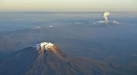
- Volcanic activity: Volcanic activity occurs at the boundaries between tectonic plates. When magma rises from the Earth's interior and reaches the surface, it erupts, forming volcanic landforms such as lava domes, cinder cones, and volcanic mountains.
- Earthquakes: The movement of tectonic plates and the associated seismic activity can cause earthquakes. Earthquakes can trigger landslides, liquefaction, and ground subsidence, significantly altering the Earth's surface.
- Ocean basins: The divergence of tectonic plates at oceanic ridges leads to the formation of new ocean crust and the expansion of ocean basins.
- Continental rifting: When continental plates move apart, it creates a continental rift, which can eventually lead to the formation of a new ocean basin. The Red Sea is an example of a continental rift.
2. Erosion
Erosion is the process of wearing away and transporting surface material by water, wind, ice, or other natural forces. Erosion shapes the landscape over long periods and contributes to the formation of various landforms.
- Water erosion: Water erosion occurs due to the flow of surface water, such as rivers, streams, and rainfall. It can create features such as valleys, canyons, and gorges.
- Wind erosion: Wind erosion takes place in arid and semi-arid environments where strong winds transport loose sediment and sculpt landforms like sand dunes and buttes.
- Glacial erosion: Glaciers move slowly across the Earth's surface, eroding the underlying bedrock and creating landforms such as fjords, cirques, and moraines.
- Coastal erosion: Coastal erosion is the wearing away of land along coastlines due to wave action, tides, and storm surges. It can lead to the formation of cliffs, headlands, and beaches.
3. Deposition
Deposition is the process of accumulating and depositing eroded materials or sediments. Depositional processes work in conjunction with erosion and contribute to shaping the Earth's landscape.
- Alluvial deposition: When rivers transport sediments and deposit them in floodplains or deltas, it leads to the formation of alluvial fans, levees, and floodplains.
- Lacustrine deposition: Sediments deposited in lakes from the surrounding land or glacier melting can create deltas, beaches, and lakebed deposits.
- Marine deposition: Marine deposition occurs in oceans, seas, and estuaries where waves, currents, and tides transport and deposit sediments, forming features like beaches, sandbars, and tidal flats.
- Aeolian deposition: Aeolian deposition involves the transport and deposition of sediments by wind. It results in the formation of sand dunes, loess deposits, and desert pavements.
These major forces—plate tectonics, erosion, and deposition—interact over long time scales to sculpt and reshape the Earth's landscape, creating the diverse and dynamic landforms we see today.