By Sarah Baczewski • Updated March 24 2022
Volcanologists face unique challenges when studying these dynamic natural systems. With limited direct access to the interior of a volcano, they rely on a suite of sophisticated instruments to monitor seismicity, temperature, ground deformation, gas emissions, and surface morphology. These tools provide real‑time data that help predict eruptions and guide emergency response.
Volcanoes are often surrounded by intense earthquake activity. Increases in seismicity can signal magma movement beneath the surface. Seismometers—also known as seimographs—record the magnitude, frequency, and epicenter of each tremor. The Hawaiian Volcano Observatory (HVO) operates more than 60 seismic stations across the Big Island, delivering high‑resolution data to researchers worldwide.
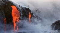
Because direct observation of a volcano’s interior is impossible, scientists use thermal imaging to capture the heat radiated from vents and fissures. Infrared cameras produce color maps that reveal which lava flows are actively warming (newer) versus those that have cooled (older). This information is crucial for assessing eruption stages and potential hazards.
Monitoring changes in a volcano’s surface shape is essential for detecting magma intrusions. Techniques include Global Positioning System (GPS), Electronic Distance Measurement (EDM), and conventional leveling. Tiltmeters, for example, measure subtle shifts in the slope of a volcano’s flank. The Hawaiian Volcano Society employs tiltmeters capable of detecting changes as small as one part per million, enabling the early detection of inflation or deflation events.
Volcanoes release a mix of gases—carbon dioxide, sulfur dioxide, hydrogen sulfide, and more—that carry fingerprints of subsurface processes. A sudden rise in sulfur or carbon dioxide can indicate fresh magma ascending, while an increase in hydrogen sulfide often precedes an eruption. To sample these gases safely, volcanologists use spectrometers that analyze the unique light signatures of each gas from a distance.
Airborne and satellite radar systems generate high‑resolution, three‑dimensional maps of a volcano’s topography. These images reveal structural features, flow paths, and potential landslide zones. Detailed radar data support not only scientific analysis but also practical evacuation planning for local authorities.
By integrating data from these diverse instruments, volcanologists create a comprehensive, real‑time picture of a volcano’s behavior, improving prediction accuracy and protecting lives.