By Christian Mullen, Updated Mar 24, 2022
Image credit: hxdbzxy/iStock/GettyImages
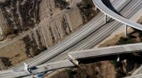
When one side of a transform boundary moves north while the other moves south—such as along the San Andreas fault—the ground shakes, causing buildings to rattle, roads to crack, and the landscape to deform. Earthquakes leave distinct marks on people, the terrain, and ecosystems.
Earth’s crust is divided into seven major plates and numerous minor ones. Their edges form transform, convergent, and divergent boundaries, each producing characteristic seismic behavior that shapes the land and impacts communities.
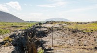
At convergent boundaries, colliding plates buckle and thrust upward, building mountain ranges or volcanic arcs, or, if one plate subducts, creating deep ocean trenches. Divergent boundaries, where plates drift apart, allow magma to surface, forming mid‑ocean ridges and sometimes volcanic islands.
Seismic waves propagate outward in concentric circles from the epicenter, and the ground’s composition dictates how fast they travel. In saturated sand or loose silt—common along coastlines and in landfill areas—soil can behave like a liquid, causing foundations to sink and structures to collapse. The same shaking can destabilize slopes, triggering landslides that fling earth, rock, and debris downhill.
In the Pacific Northwest, the 750‑mile Cascadia subduction zone brings together three distinct boundaries. A large, sustained 5‑minute quake of magnitude 9.0 could rupture the fault, generating a tsunami that would arrive 20–30 minutes later. The 2011 Tōhoku earthquake (9.1) demonstrated how such a wave can devastate coastlines. FEMA expert Ken Murphy warned in 2015 that “everything west of Interstate 5 will be toast” following a combined earthquake‑tsunami event.
Without a robust emergency plan, people can become trapped, injured, or killed during the shaking. Even when physical injuries are avoided, the trauma can leave lasting psychological scars, including post‑traumatic stress disorder that persists for years.