General Terms:
* Landforms: This is a broad term for any natural feature on the Earth's surface.
* Geomorphological features: This term is used by geologists to describe the specific landforms and their origins.
* Topographic features: This refers to the elevation and shape of the land, often depicted on topographic maps.
Specific Terms:
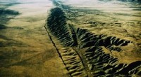
* Mountains: Elevated landforms with steep slopes and a pointed or rounded summit.
* Valleys: Depressions in the land, often formed by rivers or glaciers.
* Plateaus: Flat, elevated areas of land.
* Plains: Flat, low-lying areas of land.
* Hills: Elevated areas of land that are smaller than mountains.
* Canyons: Deep, narrow valleys carved by rivers.
* Deserts: Dry, arid areas with little vegetation.
* Forests: Areas dominated by trees.
* Oceans: Large bodies of saltwater.
* Lakes: Bodies of water surrounded by land.
* Rivers: Flowing bodies of water.
* Glaciers: Large masses of ice that flow slowly over land.
Other:
* Volcanoes: Cone-shaped mountains formed by volcanic eruptions.
* Craters: Depressions in the land caused by impacts.
* Beaches: Areas of sand or pebbles along the shoreline.
* Dunes: Hills of sand formed by wind.
The specific term used to describe a particular Earth surface feature will depend on its size, shape, and origin.