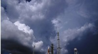
1. Instability:
- Atmospheric instability is a precursor to the formation of mammatus clouds.
- When the air near the ground is warmer and less dense than the air above it, it begins to rise, forming a convective updraft.
- As the updraft rises, it causes the air to cool and condense into clouds.
2. Downdrafts:
- As the updraft begins to lose its momentum, it starts to sink back towards the ground, forming a downdraft.
- The downdraft pushes the cloud droplets further apart and causes them to evaporate.
- This evaporation creates a pocket of cool, dense air that sinks beneath the cloud.
3. Condensation:
- As the cool air from the downdraft sinks, it mixes with the warmer, more humid air near the ground.
- This causes the water vapor in the rising air to condense into liquid droplets.
- As these droplets grow, they become visible and form the characteristic mammatus shape.
4. Shape:
- The shape of mammatus clouds is a result of the dynamic interaction between the downdraft and the rising air.
- As the downdraft pushes down, it creates a pocket of cool, dense air that is shaped like a rounded protrusion.
- The rising air then forms a bulbous shape that surrounds the pocket of cool air, giving the cloud its distinctive appearance.