1. Field Observation and Mapping:
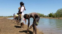
* Direct Observation: Scientists visit the location of the landform and physically observe its characteristics, including shape, size, composition, and elevation.
* Mapping: They use topographic maps, aerial photographs, and satellite imagery to create detailed maps of the landform's features.
2. Remote Sensing:
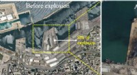
* Aerial Photography: Photos taken from planes provide a wide-angle view of the landform, revealing its overall shape and features.
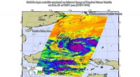
* Satellite Imagery: Satellite images capture data about the landform's elevation, vegetation, and geological composition.
* LiDAR (Light Detection and Ranging): This technique uses lasers to measure distances and create highly accurate 3D models of the landform.
3. Geological Analysis:
* Rock and Soil Samples: Scientists collect samples of rocks and soil to determine their composition and age.
* Structural Analysis: They study the geological structures (faults, folds, etc.) to understand how the landform was formed.
* Geomorphological Processes: They consider the processes that have shaped the landform, such as erosion, weathering, and deposition.
4. Geophysical Techniques:
* Seismic Surveys: These surveys use sound waves to map the underground structure of the landform.
* Gravity Surveys: Measuring variations in gravity can help identify different rock types and geological structures.
5. Digital Terrain Models (DTMs):
* Computer Models: DTMs are digital representations of the Earth's surface, providing detailed information about elevation and landform features.
6. Geographic Information Systems (GIS):
* Spatial Analysis: GIS software allows scientists to analyze and visualize landform data from multiple sources, helping them identify patterns and relationships.
7. Geochronology:
* Radioactive Dating: Scientists use radioactive dating techniques to determine the age of rocks and minerals found within the landform, providing insights into its formation history.
By combining these techniques, scientists can accurately identify and understand the formation, evolution, and characteristics of landforms. This information is crucial for various applications, including geological studies, environmental management, and resource exploration.