Geomatics is a broad term that encompasses all aspects of gathering, managing, analyzing, and presenting spatial data. It includes disciplines like:
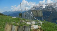
* Surveying: Measuring the Earth's surface and creating accurate maps and spatial data.
* Cartography: The art and science of mapmaking.
* Geographic Information Systems (GIS): Software and techniques for capturing, storing, analyzing, and displaying geographic data.
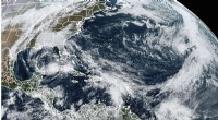
* Remote Sensing: Gathering data about the Earth's surface using sensors on satellites, aircraft, or drones.
* Photogrammetry: Using photographs to create maps and 3D models.
* Geodesy: The study of the Earth's shape and gravity field.
So, while land surveying is a specific discipline, it's part of the larger and broader field of Geomatics.