Satellites:
1. Landsat Series: The Landsat program is a joint project between the United States Geological Survey (USGS) and NASA. The Landsat satellites provide multispectral images of Earth's surface, which are used for a variety of purposes, including land use planning, agriculture, and natural resource management.
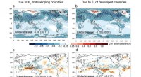
2. Sentinel Series: The Sentinel satellites are a fleet of Earth observation satellites operated by the European Space Agency (ESA). The Sentinels provide data for a wide range of applications, including land monitoring, oceanography, atmospheric science, and climate change monitoring.
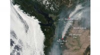
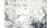
3. Terra and Aqua: Terra and Aqua are NASA's Earth Observing System (EOS) satellites, which provide continuous measurements of Earth's atmosphere, oceans, and land surface. They carry instruments that monitor key climate parameters such as temperature, humidity, precipitation, and vegetation.
4. MODIS: The Moderate Resolution Imaging Spectroradiometer (MODIS) is an instrument on board the Terra and Aqua satellites. It provides daily global images of Earth's surface, which are used for studying land cover, vegetation dynamics, and sea surface temperature.
Rovers:
1. Mars rovers: NASA has sent a series of rovers to Mars, including Sojourner (1997), Spirit and Opportunity (2004), and Curiosity (2012). These rovers have explored the Martian surface, providing valuable information about the planet's geology, atmosphere, and past climate.
2. Lunokhod 1: Lunokhod 1 was the first rover to land on the Moon. It was launched by the Soviet Union in 1970 and operated for 11 days, traversing over 10 kilometers of lunar terrain.
These are just a few examples of the many satellites and robots that have explored Earth and provided valuable data about our planet. These missions have helped us gain a better understanding of Earth's systems, resources, and environmental challenges, and have played a crucial role in advancing scientific research and technological innovations.