1. Land Use and Land Cover Mapping: Remote sensing helps classify and map land use and land cover types, such as forests, agricultural areas, urban settlements, and water bodies. This information is vital for land management, urban planning, environmental impact assessment, and agriculture monitoring.
2. Vegetation Monitoring: Remote sensing enables Earth scientists to monitor vegetation health, biomass, and changes in plant communities over time. Satellite imagery provides data on vegetation indices, leaf area index, and phenology, which are helpful in studying ecosystems, carbon cycling, and climate change impacts.
3. Soil Moisture and Water Resources Management: Remote sensing techniques can assess soil moisture content and water resources. By measuring surface temperature and vegetation water content, scientists can identify water-stressed areas and monitor groundwater levels. This information supports sustainable water resources management and drought monitoring.
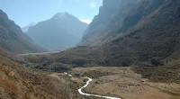
4. Geology and Mineral Exploration: Remote sensing data is used in geological mapping and mineral exploration. Satellite imagery can identify specific geological features, such as faults, folds, and mineral deposits. This aids in understanding Earth's geological structures and exploring potential mineral resources.
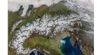
5. Snow and Ice Monitoring: Remote sensing plays a crucial role in monitoring snow and ice cover in polar regions and mountain glaciers. Satellite imagery helps track changes in ice sheets, snowpack, and sea ice extent. This information is vital for understanding climate change impacts, sea-level rise projections, and glacier dynamics.
6. Atmosphere and Weather Monitoring: Remote sensing from satellites and ground-based sensors allows scientists to study atmospheric processes and weather patterns. Parameters such as temperature, humidity, cloud cover, and air pollution levels can be measured, contributing to weather forecasting, climate modeling, and air quality assessment.
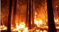
7. Natural Hazard Assessment: Remote sensing technology assists in monitoring and assessing natural hazards, including volcanic eruptions, wildfires, floods, and earthquakes. Satellite imagery provides real-time information on disaster-affected areas, enabling early warning systems and facilitating relief operations.
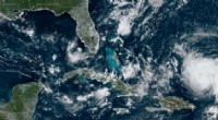
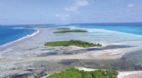
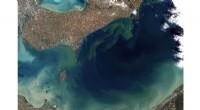
8. Oceanography and Marine Science: Remote sensing is indispensable in studying oceans, coastal dynamics, sea surface temperature, ocean currents, and marine ecosystems. Satellite imagery and sensors collect data on ocean color, sea surface height, and sea surface roughness, which helps understand marine processes and the interactions between the ocean and the atmosphere.
Overall, remote sensing is a powerful tool that equips Earth scientists with the ability to gather data on various aspects of the Earth system, enabling improved understanding of Earth processes, natural resources, and environmental changes over time.