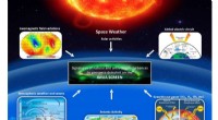
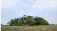
As concerns about the effects of climate change on our planet intensify, NASA satellites play a crucial role in monitoring and understanding how changing environmental conditions impact forest ecosystems. These advanced Earth-observing satellites provide invaluable data and imagery that help scientists, researchers, and policymakers gain insights into the intricate relationship between climate change and forest health.
1. Detecting Deforestation and Land Use Changes:
- Satellites can track changes in forest cover over time, enabling the detection of deforestation and land use changes.
- By analyzing satellite imagery, experts can identify areas where forests have been cleared for agriculture, urbanization, or other human activities.
2. Monitoring Forest Health and Canopy Changes:
- Satellites collect data on the health and vitality of forests.
- Spectral measurements from satellites help identify vegetation stress caused by factors such as drought, insect infestations, or diseases.
- Changes in canopy structure, leaf area, and photosynthetic activity can be detected using satellite observations.
3. Measuring Forest Biomass and Carbon Stocks:
- Satellites can estimate the amount of above-ground biomass in forests, which is crucial for assessing carbon storage capacity.
- Monitoring changes in forest biomass provides insights into the global carbon cycle and its response to climate change.
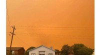
4. Observing Forest Disturbances and Natural Disasters:
- Satellites can detect and monitor natural disturbances like wildfires, hurricanes, and pest infestations.
- By analyzing satellite data, scientists can understand the extent and impact of these disturbances on forest ecosystems.
5. Predicting Future Forest Conditions:
- Satellite-derived data combined with climate models helps scientists predict how forests may respond to future climate scenarios.
- These predictions support proactive management strategies and conservation efforts.
6. Supporting Sustainable Forest Management:
- Satellite data aids in developing sustainable forest management practices by providing information about forest resources and their condition.
- This knowledge helps policymakers and land managers make informed decisions to protect forest ecosystems.
7. Contributions to Global Climate Research:
- Satellite observations of forests contribute to our understanding of the Earth's climate system and its interactions with forests.
- Data from satellites complements other ground-based measurements, enhancing our ability to study complex environmental processes.
8. Tracking Changes in Biodiversity and Habitat:
- Satellites help identify critical forest habitats and monitor changes in biodiversity.
- This information supports efforts to conserve biodiversity and protect wildlife.
9. Engaging the Public and Raising Awareness:
- Satellite imagery and data can be presented in user-friendly formats to engage the public and raise awareness about the importance of forests.
In conclusion, NASA satellites provide a powerful tool for studying the effects of climate change on forests. They enable scientists and decision-makers to gain valuable insights into the health, dynamics, and resilience of forest ecosystems in a rapidly changing world. By harnessing the power of satellite technology, we can better understand and mitigate the impacts of climate change on our precious forests.