1. Upper-level Winds: The prevailing upper-level winds during the bushfire season were conducive to the long-range transport of smoke. These winds carried large smoke plumes eastward from Australia across the Pacific Ocean.
2. Atmospheric Circulation Patterns: The large-scale atmospheric circulation patterns, such as the Hadley Cells, facilitated the global dispersion of smoke particles. Air in the tropics rises and moves toward the poles, while descending air at mid-latitudes completes the circulation. This global airflow pattern helped distribute smoke from the bushfires to various parts of the world.
3. Stratospheric Injection: Some smoke particles injected into the upper atmosphere (stratosphere) through convection and other atmospheric processes. This injection resulted in the spread of smoke over vast distances, including reaching the Southern Hemisphere.
4. Suspension in the Atmosphere: Fine smoke particles emitted from the fires had small sizes, allowing them to stay suspended in the atmosphere. This extended the duration of smoke transport and enabled its long-distance travel.
5. High-Pressure Systems: Persistent high-pressure systems played a role in trapping the smoke at lower altitudes, preventing its upward dispersion. This contributed to the accumulation and spread of smoke across the affected regions.
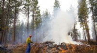
The bushfire smoke impacted air quality in several countries, including New Zealand, Chile, Argentina, South Africa, and even reached as far as the west coast of North America and parts of South America. The smoke caused respiratory and health problems, reduced visibility, and affected weather conditions in the affected regions.
To monitor the movement of bushfire smoke, agencies such as NASA, the European Centre for Medium-Range Weather Forecasts (ECMWF), and various national weather services used satellite imagery, atmospheric models, and dispersion forecasts. This information was disseminated to raise public awareness, issue air quality alerts, and support decision-making related to health and environmental management.