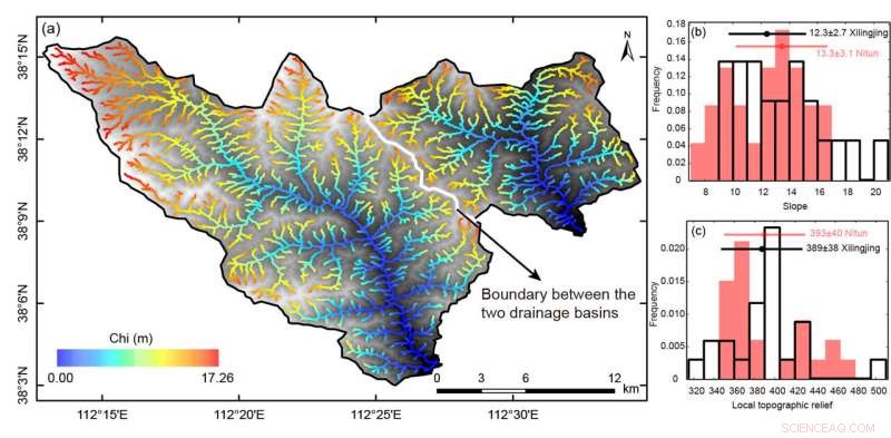
The left panel shows the chi map of the two sampled catchments. The right upper panel is the Statistical histogram of the river head slope on both sides of the catchment boundary. The right low panel shows the statistical histogram of the local relief of river heads. Credit: Science China Press
The erosional landscape evolves as the joint product of both tectonic activity and climate. The morphology of the long profiles of active rivers has been proven to be an archive to preserve and record the relationship of topographic relief, temporary and/or differential rock uplift rate, and climatically and/or lithologically related erosional efficiency. A simple but universal equation of the stream-power incision model provides an important means to analyze channel long profiles and to extract both temporal and spatial patterns of regional tectonic activity.
Based on the analytical solutions to the steady-state and linear transient-state forms of the model equation, researchers developed a set of open-source Matlab scripts, RiverProAnalysis, to integrate the functions of drainage basin concavity calibration, channel steepness estimate, drainage divide stability determination, paleo-channel profile projection, and tectonic uplift history inversion.
The products of the tool set are in the format of image, text, and vector files, which not only can be used for visual analysis, but also be read by geographic information system software.
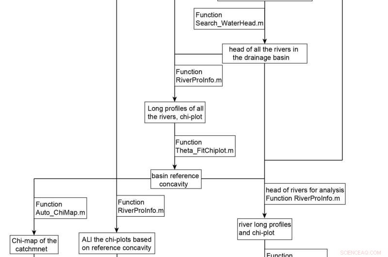
The flowchart tells the functions of the program and the input data and output results of each function. Credit: Science China Press
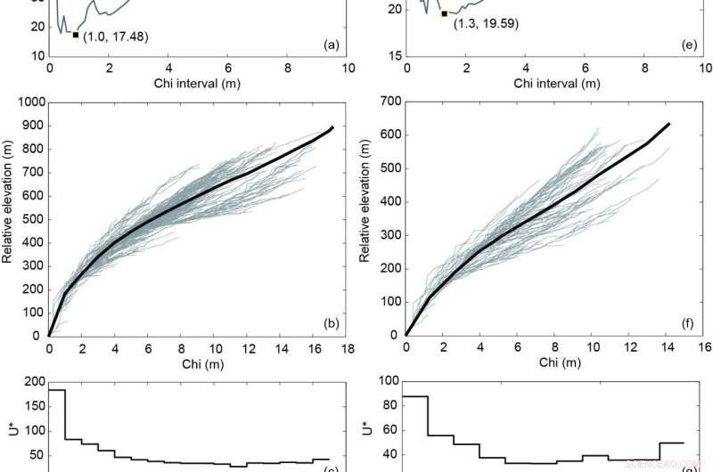
(a) The Xilingjing catchment: Elevation misfit between the forwarded and actual channel chi-plots, under different Chi value intervals. (b) The chi-plots of all the rivers in the Xilingjing catchment and the forwarded channel chi-plot are based on chi interval of 1.0 m (black thick line). (c) Dimensionless uplift history. (d) The modeled uplift history based on different erodibility values. (e)‒(h) Uplift history inversion on the Nitun catchment. The meaning of each figure is the same from (a) to (d). Credit: Science China Press
To illustrate the ability of the tool set, the authors took examples of two transient drainage catchments in the northern margin of the Taiyuan Basin. They analyzed the long profiles of the trunk streams, identified two generations of knickpoints, and estimated the minimum depth of river incision.
They combined all the trunk and tributary channels together to model the catchment-wide uplift history and found moderate increases in the uplift rates since the Middle Pliocene and rapid acceleration since the late Quaternary.
The results were consistent with the sedimentary records in the adjacent basin. By comparing the chi value, slope, and topographic relief of both sides of the catchment divide, they concluded the stability of the drainage divide.
The tool set described in this study integrates the main functions of the modern studies on fluvial landscape, thus providing a powerful tool for analyzing river long profiles and for understanding tectonic geomorphology.
The research was published in Science China Earth Sciences. + Explore further