By Diana K. Williams, Updated Aug 30, 2022
fotoguy22/iStock/GettyImages
Landforms are natural features shaped solely by geological processes. Though the Midwest is often perceived as flat, it hosts a diverse array of elevations—rolling hills, modest mountains, and expansive valleys—alongside vast plains, plateaus, and lakes. The region includes Ohio, Michigan, Indiana, Illinois, Iowa, Kansas, Nebraska, Missouri, Wisconsin, North Dakota, South Dakota, and Minnesota.
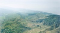
The Great Plains dominate the central Midwest, stretching from Missouri and Nebraska northward into the Dakotas. These expansive grasslands, largely treeless, boast fertile soils that support extensive agriculture. Adjacent to the plains are plateaus—flat elevated surfaces surrounded by steep escarpments. The Appalachian Plateau in eastern Ohio and the Ozark Plateau, which spans southern Missouri and portions of Kansas and Illinois, exemplify these higher‑elevation plains.
The Ozark Mountains, a heavily forested highland region, cut across Missouri, southern Illinois, and southeastern Kansas. Hills arise from erosion or as remnants of weathered mountains. The Black Hills of western South Dakota illustrate this process: uplifted rock that was later sculpted by wind and water. At 1,772 ft (541 m), Taum Sauk Mountain in Missouri stands as the state’s highest peak and the tallest point in the Midwest.
While rivers and lakes are dynamic water bodies, they also qualify as natural landforms. The Great Lakes—Erie, Superior, Huron, Michigan, and Ontario—border Ohio, Michigan, Indiana, Illinois, and Wisconsin, collectively holding 20% of the world’s freshwater. Major rivers shaping the Midwest include the Mississippi, flowing from northwest Minnesota to the Gulf of Mexico; the Ohio, forming southern borders of Ohio, Indiana, and Illinois; and the Missouri, the longest river in the United States, traversing the Midwest into the western states.
Valleys are long, low‑lying depressions formed by persistent water or glacial erosion, typically sloping toward a watercourse. The Ohio, Missouri, and Mississippi valleys are prominent in the Midwest. The Badlands of western South Dakota differ by featuring narrow ravines, buttes, and ridges carved by wind and water into sedimentary rock.
For authoritative geological details, see the U.S. Geological Survey.