Landforms:
* Canyons: Deep, narrow valleys carved by rivers over millions of years. The Grand Canyon is a prime example.
* Caves: Formed by the dissolving action of acidic groundwater on soluble rocks like limestone.
* Arches: Natural rock formations shaped by wind and water erosion, often found in arid regions.
* Hoodoos: Tall, thin spire-like rock formations, usually found in desert areas.
* Badlands: Rugged, barren landscapes with deeply eroded canyons and gullies.
* Mesas and Buttes: Flat-topped hills with steep sides, formed by erosion of surrounding softer rock.
* Sand Dunes: Accumulations of sand deposited and shaped by wind.
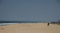
* Beaches: Coastal landforms composed of sand, gravel, or other sediments deposited by waves and currents.
* River Valleys: Low-lying areas formed by the erosive power of rivers.
* Delta: A fan-shaped deposit of sediment formed at the mouth of a river.
Other Structures:
* Sea Cliffs: Steep rock faces formed by wave erosion along coastlines.
* Sea Stacks: Isolated rock formations separated from the mainland by wave erosion.
* Wave-cut Platforms: Flat, rocky surfaces carved out by waves at the base of cliffs.
* Glacial Valleys: U-shaped valleys formed by the erosive power of glaciers.
* Cirques: Bowl-shaped depressions at the head of glacial valleys.
* Fjords: Long, narrow inlets formed by glacial erosion.
Note:
* Erosion is a continuous process, constantly shaping and reshaping the Earth's surface.
* The type of erosion (water, wind, ice, etc.) and the type of rock play a crucial role in determining the resulting landform.
* Human activities like deforestation and agriculture can significantly accelerate erosion rates.
It's worth noting that erosion can also create features that are not always considered "structures," such as soil degradation, land subsidence, and even the formation of sinkholes.