1. Paleomagnetism:
* Method: The Earth's magnetic field flips its polarity over time. When rocks form, they record the magnetic field's direction.
* Evidence:
* Striped patterns on the ocean floor: Magnetic stripes, alternating in polarity, are found symmetrically on either side of mid-ocean ridges. This indicates seafloor spreading and plate movement.
* Matching paleomagnetic records on different continents: Similar paleomagnetic patterns found on continents now separated by vast oceans provide compelling evidence for their former connection.
2. Seismology:
* Method: Using seismographs to detect and analyze earthquake waves.
* Evidence:
* Epicenter locations: Earthquakes predominantly occur along plate boundaries, confirming their locations as zones of tectonic activity.
* Wave propagation: The way seismic waves travel through the Earth reveals the structure of the mantle and its relationship to plate movement.
3. GPS (Global Positioning System):
* Method: Satellites track the precise locations of points on Earth's surface over time.
* Evidence:
* Plate motion measurements: GPS data shows that continents and ocean plates are constantly moving, even if at very slow rates (centimeters per year).
4. Ocean Floor Topography:
* Method: Using sonar mapping to create detailed images of the ocean floor.
* Evidence:
* Mid-ocean ridges: These underwater mountain ranges mark areas where new crust is being formed.
* Deep-sea trenches: These are deep, narrow depressions that form along the edges of some plates, where one plate subducts (slides) beneath another.
5. Geochronology:
* Method: Radioactive dating of rocks to determine their age.
* Evidence:
* Age of ocean floor: Rocks on the ocean floor are much younger than those on the continents, supporting the idea of continuous seafloor spreading.
* Matching rock ages on different continents: Similar aged rocks found on different continents can indicate their former connection.
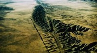
6. Satellite Imagery:
* Method: Taking images of Earth from space to observe features and changes over time.
* Evidence:
* Plate boundaries: Satellite imagery can reveal the topography of plate boundaries, including faults and volcanoes, providing visual evidence of tectonic activity.
* Changes in landforms: Satellite images can monitor shifts in landforms over time, indicating tectonic movement.
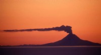
7. Hot Spot Volcanism:
* Method: Studying volcanic activity that is not associated with plate boundaries.
* Evidence:
* Linear chains of volcanoes: Hot spots, which are plumes of rising mantle material, create chains of volcanoes as the plate moves over them. This provides evidence of both plate movement and the existence of these plumes.
These technological methods, taken together, provide a comprehensive picture of plate tectonics and its influence on the Earth's surface and deep interior.