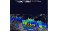
Geoelectric sounding is a geophysical method used to investigate the subsurface by measuring the electrical resistivity of the ground. This technique provides insights into the aquifer's properties, such as:
1. Depth and Thickness:
* By analyzing the changes in resistivity with depth, one can delineate the boundaries of different geological layers, including the aquifer.
* This information is crucial for determining the aquifer's thickness, which directly impacts its water storage capacity.
2. Aquifer Material:
* Different geological materials have distinct electrical resistivities.
* Analyzing the resistivity values can help identify the type of aquifer material, such as sand, gravel, or clay.
* This information is crucial for understanding the aquifer's hydraulic conductivity, which relates to the ease with which water can flow through the material.
3. Aquifer Water Content:
* Water is a good conductor of electricity, while the surrounding rock and soil usually have higher resistivity.
* By comparing the resistivity values with the known properties of the aquifer material, we can infer the amount of water present within the aquifer.
* This helps to estimate the aquifer's porosity, which is the percentage of void space available for water storage.
4. Salinization and Contamination:
* Dissolved salts and contaminants in groundwater can significantly alter its conductivity.
* Analyzing the resistivity profiles can help detect variations in salinity and contamination levels within the aquifer.
* This is essential for understanding the quality of the groundwater and potential risks associated with its use.
5. Groundwater Flow:
* By conducting geoelectric soundings at different locations and comparing the results, one can infer the direction and magnitude of groundwater flow.
* This information is crucial for understanding the groundwater recharge and discharge zones, as well as for managing water resources effectively.
How it Works:
* Geoelectric sounding involves injecting a current into the ground using electrodes and measuring the resulting voltage at different distances from the current source.
* The resistivity of the subsurface is calculated based on the measured voltage and current values.
* By using multiple electrode configurations and varying the distances between them, the resistivity is measured at various depths, creating a resistivity profile.
* The resistivity profile is then analyzed to interpret the geological layers and their properties.
Limitations:
* The interpretation of geoelectric sounding data can be complex and requires expertise.
* The method is sensitive to variations in soil moisture and temperature, which can influence the resistivity readings.
* Geoelectric sounding may not be suitable for areas with highly conductive materials, such as metallic ores.
Conclusion:
Geoelectric sounding is a valuable tool for predicting aquifer properties and understanding the behavior of groundwater systems. It can help in the sustainable management of water resources by providing crucial information about the location, thickness, material, water content, salinity, and flow patterns of aquifers. However, it's essential to consider the limitations of the method and interpret the data with caution.