1. Geological Activity:
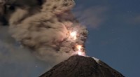
* Volcanic Activity: Active volcanoes are a clear sign of ongoing mountain formation. Eruptions deposit lava and ash, building up the mountain's height over time.
* Earthquakes: Frequent earthquakes, especially those along fault lines, indicate tectonic activity that can uplift mountains.
* Hot Springs and Geysers: These features often signify geothermal activity, suggesting a source of heat and energy that can contribute to mountain formation.
2. Physical Characteristics:
* Elevation Changes: Precise elevation measurements over time can reveal gradual increases in a mountain's height, indicating ongoing uplift.
* Rock Formations and Deformation: Geologists analyze rock formations and the presence of folds, faults, and other deformations to understand the history of tectonic forces that shaped the mountain.
* Erosion Patterns: While erosion can wear down mountains, the rate of erosion can be compared to the rate of uplift. If uplift is faster than erosion, the mountain is still growing.
3. Satellite Imagery and GPS Data:
* Satellite imagery: Satellites can monitor changes in landforms over time, including the subtle movements of mountains caused by tectonic activity.
* GPS data: GPS sensors placed on mountains can precisely track their movements, revealing subtle uplift or subsidence.
4. Geological History:
* Past Tectonic Events: Understanding the geological history of a region can help predict future mountain formation. For example, regions with a history of tectonic collisions are more likely to experience ongoing mountain building.
Note:
* Not all mountains are actively forming. Many mountains are simply eroded remnants of past tectonic activity.
* Determining whether a mountain is still forming can be a complex process requiring multiple lines of evidence.
By combining these observations and analysis techniques, geologists can gain a deeper understanding of the dynamics of mountain formation and determine if a specific mountain is still actively growing.