However, this is just an average. The geothermal gradient can vary significantly depending on several factors, including:
* Location: Geothermal gradients are higher in areas with active volcanism or tectonic plate boundaries.
* Rock type: Some rocks are better conductors of heat than others.
* Depth: The gradient tends to decrease with increasing depth.
* Heat flow from the mantle: This can vary significantly in different regions.
Here are some examples of how the geothermal gradient can vary:
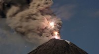
* Near volcanic areas: The geothermal gradient can be as high as 100°C per kilometer.
* In areas with stable crust: The geothermal gradient can be as low as 10°C per kilometer.
It's important to note:
* The geothermal gradient is not linear. It typically increases more rapidly at shallower depths and then levels off at greater depths.
* The actual temperature at a given depth can be affected by other factors such as groundwater flow.
Therefore, the average geothermal gradient of 25-30°C per kilometer is just a general guideline. It's best to consult local geological data for more accurate estimates in specific areas.