1. Rock Observations:
* Rock Types: Identifying the different types of rocks (igneous, sedimentary, metamorphic) provides insights into the processes that formed them.
* Fossils: Fossil remains within sedimentary rocks tell us about past life, environments, and climate.
* Rock Layers (Strata): The order of rock layers, called stratigraphy, helps determine relative ages and the sequence of events that occurred over time.
* Rock Structures: Features like folds, faults, and intrusions reveal tectonic activity, mountain building, and deformation.
* Mineral Composition: Analyzing the minerals within rocks provides information about the temperature and pressure conditions at the time of formation.
2. Surface Features:
* Landforms: Features like mountains, valleys, canyons, and plains are shaped by geological processes and can indicate past events like erosion, deposition, or volcanic activity.
* Erosion Patterns: Observing how erosion patterns shape the landscape reveals the direction and magnitude of past forces like wind, water, or glaciers.
* Soil and Sediment: Studying the composition, texture, and layering of soil and sediment provides clues about past environments and climatic conditions.
3. Geophysical Data:
* Seismic Waves: Analyzing seismic waves generated by earthquakes allows scientists to map the Earth's internal structure, identify fault lines, and study the composition of different layers.
* Gravity Anomalies: Variations in the Earth's gravity field can indicate the presence of dense or less dense rock bodies, providing insights into geological structures.
* Magnetic Anomalies: Variations in the Earth's magnetic field can reveal the movement of tectonic plates and the formation of magnetic reversals over time.
4. Chemical and Isotopic Analysis:
* Radiometric Dating: Analyzing radioactive isotopes within rocks provides accurate ages for geological events.
* Geochemical Analysis: Studying the chemical composition of rocks and minerals helps understand their origin, formation conditions, and interactions with fluids.
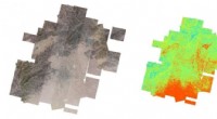
5. Remote Sensing:
* Satellite Imagery: Satellite images can provide large-scale views of geological features, identify areas of interest, and monitor changes over time.
* Aerial Photography: Aerial photography can be used to map geological features and study their spatial relationships.
By carefully combining and interpreting these different observations, scientists can piece together a comprehensive picture of Earth's geological history, providing insights into past climates, environments, tectonic activity, and the evolution of life on our planet.