Geological data encompasses any information about the Earth's physical structure, composition, and processes. It's the foundation of understanding our planet's history, resources, and hazards.
Here's a breakdown of geological data types:
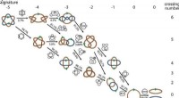
1. Rock & Mineral Data:
* Composition: Identifying minerals and their proportions in rocks, using techniques like petrography, X-ray diffraction, and chemical analysis.
* Structure: Studying rock textures, layering, and deformation features, revealing processes like sedimentation, volcanism, or tectonic activity.
* Age: Using radioactive dating methods to determine the age of rocks and geological events.
2. Geophysical Data:
* Gravity: Measuring variations in Earth's gravity field to map subsurface structures, like ore deposits or underground cavities.
* Magnetic: Detecting changes in Earth's magnetic field, revealing anomalies associated with mineral deposits, fault zones, or volcanic activity.
* Seismic: Studying seismic waves generated by earthquakes to map the Earth's interior, locate faults, and assess earthquake hazards.
* Electrical: Measuring electrical conductivity of the subsurface, revealing groundwater presence, mineral deposits, or geological structures.
3. Geochemical Data:
* Isotope analysis: Analyzing the ratios of different isotopes in rocks, minerals, and water to trace geological processes, understand climate change, or reconstruct past environments.
* Elemental analysis: Determining the concentration of elements in rocks, soils, and water, revealing information about geological processes, pollution, and resource distribution.
4. Geospatial Data:
* Topographic maps: Representing Earth's surface elevation and features, essential for geological mapping and hazard assessment.
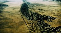
* Satellite imagery: Capturing high-resolution images of the Earth's surface, enabling monitoring of geological processes like landslides, volcanic activity, and glacial retreat.
* Geographic information systems (GIS): Storing, managing, and analyzing geospatial data, facilitating geological mapping, resource exploration, and environmental assessment.
5. Other Data Types:
* Paleontological data: Fossils and their distribution provide insights into Earth's past environments, climate change, and evolution.
* Hydrological data: Information about groundwater flow, surface water, and water quality, crucial for resource management and environmental protection.
* Geotechnical data: Characterizing soil and rock properties for engineering purposes, like construction and infrastructure projects.
Applications of Geological Data:
Geological data is vital for various disciplines:
* Resource Exploration: Identifying and evaluating deposits of oil, gas, minerals, and groundwater.
* Hazard Assessment: Predicting and mitigating risks from earthquakes, volcanic eruptions, landslides, and other geological hazards.
* Environmental Management: Understanding groundwater contamination, soil erosion, and other environmental issues.
* Climate Change Research: Reconstructing past climate changes, understanding present-day climate patterns, and predicting future changes.
* Earth Science Education: Educating students about the Earth's history, processes, and resources.
The Future of Geological Data:
With advancements in technology, geological data is becoming more abundant, detailed, and integrated. This allows for more accurate and comprehensive analysis, leading to improved decision-making in resource management, hazard mitigation, and environmental protection.