However, there are several map projections that attempt to minimize certain types of distortion:
* Mercator projection: This projection is commonly used for world maps. It preserves angles, making it useful for navigation, but it distorts areas, particularly at the poles. Greenland appears much larger than South America, for example, even though it is actually much smaller.
* Gall-Peters projection: This projection preserves areas, meaning that continents are shown in their true relative sizes. However, it distorts shapes and angles, making it less useful for navigation.
* Robinson projection: This projection balances distortion across the map, but it doesn't accurately preserve angles or areas. It is a popular choice for general-purpose maps.
* Winkel Tripel projection: This projection minimizes distortion across the map, making it a good choice for world maps. It is a compromise between the Mercator and Gall-Peters projections.
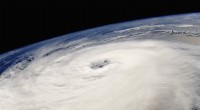
Other ways to visualize Earth's curvature:
* Photographs from space: Images of Earth taken from satellites clearly show its curved surface.
* Circumnavigation: When a person or object travels all the way around the Earth, they are experiencing its curvature.
* Observing ships disappearing over the horizon: As ships sail away, they gradually disappear hull first, demonstrating that the Earth is curved.
No map projection can perfectly capture the curvature of the Earth, but by understanding the limitations of each projection, we can choose the best one for our specific needs.