Here's why:
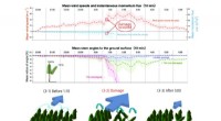
* Topographic maps use contour lines to represent changes in elevation. These lines connect points of equal elevation, allowing you to visualize the shape and slope of the land.
* Water depth is often indicated on topographic maps using a special symbol or color, usually in conjunction with contour lines.
While other types of maps might show some aspects of elevation or water depth, topographic maps are specifically designed to represent both with high accuracy.