Before Remote Sensing:
* Limited Scope: Geographic data relied heavily on ground-based surveys, which were time-consuming, expensive, and often limited to small areas.
* Inaccessible Areas: Collecting data in remote or dangerous locations was extremely challenging and often impossible.
* Limited Frequency: Data was collected infrequently due to the logistical challenges involved, making it difficult to track changes over time.
* Subjective Interpretations: Data interpretation relied heavily on human judgment, leading to potential biases and inaccuracies.
Impact of Remote Sensing:
* Expanded Scope: Remote sensing sensors aboard satellites and aircraft can collect data over vast areas, providing a global perspective.
* Access to Remote Areas: Data can be obtained from areas that are inaccessible or dangerous for traditional methods, allowing for exploration of previously uncharted territories.
* Frequent Data Collection: Sensors can collect data regularly, providing insights into dynamic processes and changes over time, such as land use, deforestation, and climate change.
* Objective Data: Remote sensing data is objective and quantifiable, reducing human bias and improving the accuracy of interpretations.
* Multi-spectral Data: Remote sensing provides data across multiple wavelengths, enabling detailed analysis of different features and materials on the Earth's surface.
Specific Examples:
* Mapping of land use and land cover: Remote sensing images help track changes in deforestation, urbanization, and agricultural practices.
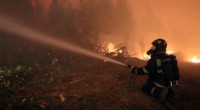
* Monitoring natural disasters: Satellite imagery helps assess the impact of earthquakes, floods, and wildfires, enabling faster response and aid distribution.
* Precision agriculture: Remote sensing data allows farmers to monitor crop health, identify pests and diseases, and optimize resource use.
* Climate change studies: Remote sensing data provides insights into changes in sea level, ice caps, and glaciers, helping scientists understand the impact of climate change.
Overall, remote sensing offers a transformative approach to geographic data acquisition, enabling us to understand and manage our planet more effectively.