Geography
The Great Plains is a vast, flat region with few natural barriers to block the flow of air. This allows cold air from the north and warm air from the south to meet and clash, creating storms. The plains are also located in the middle of the continent, far from the moderating effects of the oceans. This means that the weather in the Great Plains can be more extreme than in other parts of the country.
Climate
The Great Plains has a continental climate, with hot summers and cold winters. The average temperature in July is around 90 degrees Fahrenheit, while the average temperature in January is around 20 degrees Fahrenheit. The region also experiences a lot of precipitation, with an average of 30 inches of rain or snow per year.
Jet Stream
The jet stream is a fast-moving band of air that flows high in the atmosphere. The jet stream can affect the weather in the Great Plains by bringing cold air from the north or warm air from the south. When the jet stream is strong, it can create storms. When the jet stream is weak, the weather in the Great Plains can be more calm.
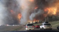
All of these factors combine to create the epic weather that is characteristic of the Great Plains. The region is known for its tornadoes, thunderstorms, blizzards, and droughts. These storms can cause extensive damage and loss of life. However, they are also part of what makes the Great Plains a unique and fascinating region.