1. Unstable Air: The air needs to be unstable, meaning it's warm and moist near the surface and cooler and drier aloft. This creates a situation where the warm air wants to rise, but is held down by the heavier cold air above.
2. Lifting Mechanisms: Something needs to lift the air to trigger cloud formation. This can be caused by:
* Convection: When the sun heats the ground, the warm air rises, carrying moisture with it.
* Fronts: When warm air meets cold air, the warm air rises over the cold air.
* Orographic lift: When air is forced upwards by mountains or hills.
* Convergence: When air flows together, it is forced upwards.
3. Condensation: As the warm, moist air rises, it cools due to the lower atmospheric pressure at higher altitudes. This cooling causes the water vapor in the air to condense into tiny water droplets, forming clouds.
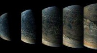
4. Stratocumulus Formation: The key to stratocumulus clouds is that the lifting mechanism doesn't push the air very high. This results in a shallow layer of clouds that spread out horizontally. The droplets in these clouds are also relatively large, giving them a lumpy, rounded appearance.
5. Appearance: Stratocumulus clouds are often described as "patches" or "rolls". They typically appear in grayish-white patches with darker areas, creating a distinctive, "layered" look. These clouds can cover large areas of the sky.
In Summary:
Stratocumulus clouds occur when unstable air is lifted by various mechanisms, causing moisture to condense into large droplets within a shallow layer of the atmosphere. Their lumpy, rounded appearance is due to the relatively large size of the water droplets and their horizontal spread.